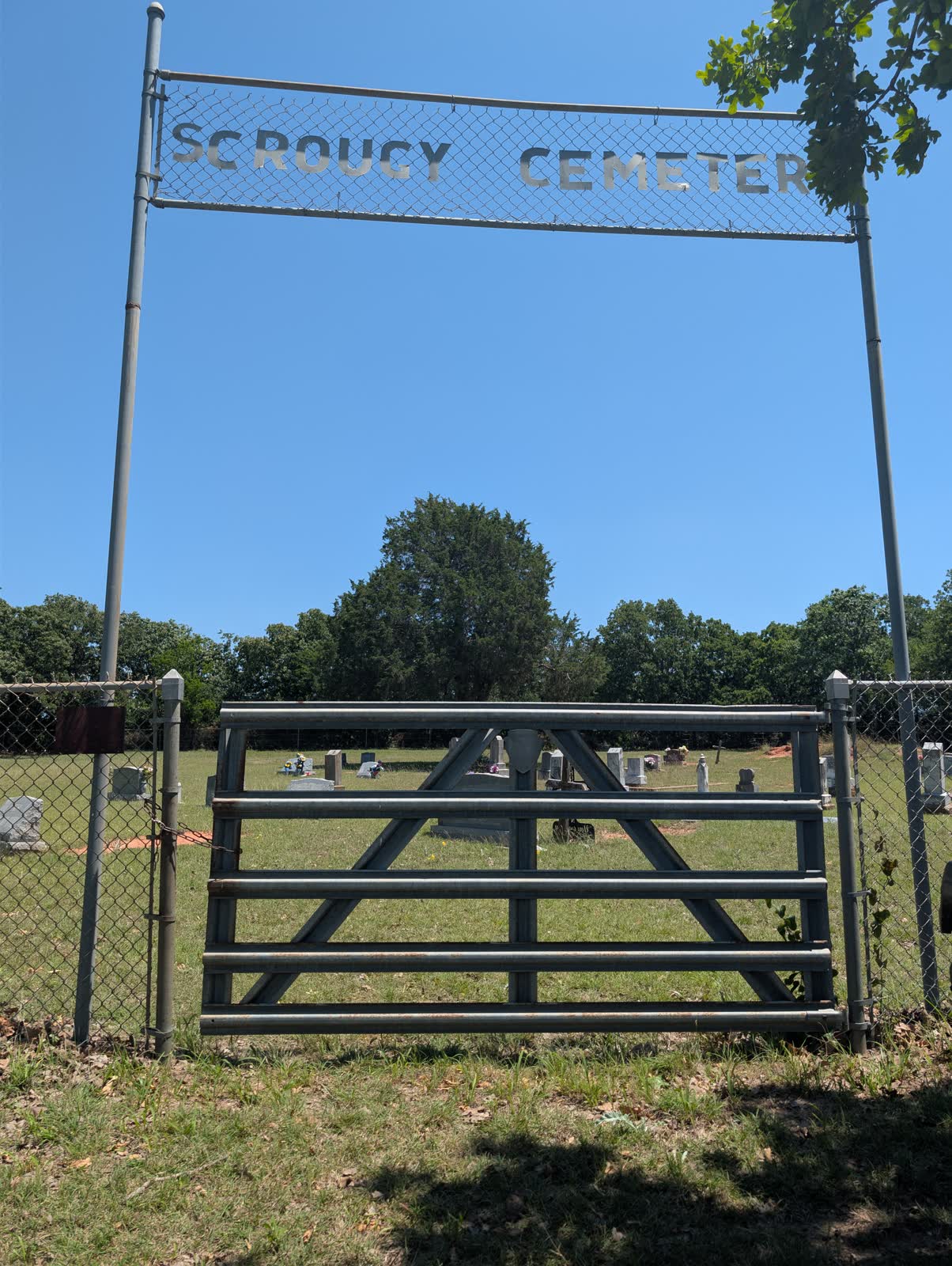
Scrougy Cemetery — known also as Prospect Cemetery, and sometimes listed in county inventories under the conflated triple name “Scrougy / Huddleston / Prospect” — is a rural community burial ground on Farm Road 1749 in the central-southern portion of Montague County. It serves, or once served, a dispersed agricultural community in the Cross Timbers interior between Forestburg and Sunset. Documentation is sparse, the cemetery has not been systematically surveyed in modern records, and several facts about it that one would expect to find — establishment date, burial count, founding family — are not confirmed in available primary sources. What is confirmed, and what this page records honestly, is the cemetery’s existence, its location, its name history, and its place within a significant cluster of community burial grounds along a single farm road.
Name History and Disambiguation
The three-name designation “Scrougy / Huddleston / Prospect” that appears in some Montague County cemetery inventories is partially incorrect and requires correction here.
Scrougy and Prospect are the same cemetery. The Genealogy Trails Montague County cemetery list — the most comprehensive publicly available cemetery inventory for the county — lists “Scougy Cemetery” (a spelling variant of Scrougy) at FM 1749. It does not list a separate “Prospect Cemetery” at any location, which strongly indicates that Prospect is a local alias for the same ground rather than a distinct burial ground. The canonical name for this cemetery is Scrougy (or Scougy — both spellings appear in historical records); Prospect should be understood as an alternate local reference, not a separate site.
Huddleston is a different cemetery. The Genealogy Trails inventory lists “Huddleston Cemetery” at the Forestburg-Sunset border — a location approximately 8–10 miles north of Scrougy on FM 1749. The Genealogy Trails “Fryer Cemetery” entry explicitly notes its proximity to Huddleston, placing Fryer near the Forestburg-Sunset border rather than near FM 1749’s central corridor. These geographic details confirm that Huddleston and Scrougy/Prospect are separate cemeteries. The triple-name inventory entry that combines them appears to be a historical conflation error.
For researchers: any search for Scrougy Cemetery, Scougy Cemetery, or Prospect Cemetery (FM 1749, central Montague County) should be understood as searching for the same burial ground. Any search for Huddleston Cemetery should be directed toward the Forestburg-Sunset border, a separate location.
The Name Itself: What “Scrougy” Means
“Scrougy” (or “Scougy”) is an unusual cemetery name. Unlike the aspirational naming conventions common in 19th-century Texas burial grounds — “Pleasant Hill,” “Mount Zion,” “Harmony,” “Rest Haven” — Scrougy does not follow any obvious euphemistic or topographic formula. The most likely explanations are either a family surname (a Scrougy or Scougy family associated with the original burial ground or the surrounding land) or a local geographic or colloquial term whose meaning has been lost to general usage but was understood by the settlement community that named it.
The “Prospect” alias follows a different naming pattern — “Prospect” was commonly used in 19th-century Texas to describe communities, churches, and associated burial grounds with optimistic connotations about the area’s future. “Prospect Cemetery” as a local name for a burial ground that was formally or more widely known as Scrougy suggests a community that had two reference points for the same place, one more formal or traditional, the other more aspirational.
Neither the family-name hypothesis for Scrougy nor the community-optimism reading of Prospect has been confirmed by primary source research. Both are offered here as interpretive possibilities, not established facts.
Location and the FM 1749 Corridor
Scrougy/Prospect Cemetery sits on or near FM 1749 in central-southern Montague County, in the interior Cross Timbers agricultural zone between Forestburg (north) and Sunset (south). The specific access point, GPS coordinates, and physical condition of the cemetery are not confirmed without field survey.
FM 1749 carries a notably dense concentration of community cemeteries for a single farm road. Within the corridor, the documented cemeteries include:
- Scrougy/Prospect Cemetery (this cemetery)
- Pleasant Hill Cemetery (FM 1749 — distinct from Scrougy; listed as a separate Genealogy Trails entry)
- Pleasant Valley Cemetery (FM 1749 — distinct from Pleasant Hill; separate entry)
- Lake Valley Cemetery (FM 1749)
- Jackson/Old Liberty Cemetery (FM 1749)
Five or more documented burial grounds along a single farm road in the county’s interior reflects a dispersed, self-organizing settlement pattern. Each cemetery served a distinct cluster of farm families who were close enough to share a road but sufficiently autonomous — geographically, socially, or denominationally — to maintain their own burial ground rather than sharing a common cemetery with neighbors a mile or two away. This pattern is characteristic of upland-Southern settlement in the Cross Timbers, where Lynette Schroeder’s 1974 thesis on burial traditions in Montague County documented family-centered and community-centered burial practices that resisted consolidation until well into the 20th century.
Settlement Context
The FM 1749 interior of Montague County was settled primarily by farming families from upland-Southern states — Missouri, Arkansas, Tennessee, Kentucky, and Alabama — beginning in the 1850s and 1860s. This migration wave followed county formation in 1857 and intensified after the Civil War, when land prices in Texas drew veterans and farming families looking for fresh starts.
The Cross Timbers zone these settlers entered was not empty. Comanche and Kiowa raiding parties moved through this corridor during the 1860s and 1870s — the Illinois Bend raid of 1863, the Perryman Cemetery’s documentation of a well-digger killed by Indians in 1863, and the broader pattern of frontier violence along the Red River corridor all touch this geographic zone. Settlement in the FM 1749 interior in those years meant accepting significant risk. The community cemeteries that formed along the corridor in that period — including, presumably, Scrougy/Prospect — contain burials from that era of frontier tension, though specific burial names from that period have not been documented for this cemetery.
By the 1880s and 1890s, as raiding ceased and the cattle and cotton economies developed, the FM 1749 corridor settled into the quieter rhythms of agricultural life. The five corridor cemeteries persisted, each maintained by the families who buried their dead there, while the county’s population began its long consolidation toward the larger towns along the railroad corridors.
What is not yet documented
The research record for Scrougy/Prospect Cemetery is among the thinnest in the Montague County cemetery inventory. Not confirmed in available primary sources:
- Establishment date
- Earliest known burial
- Founding family or land donor
- Interment count
- HTC (Historic Texas Cemetery) designation
- THC historical marker
- GPS coordinates
- Current maintenance organization
- Find A Grave cemetery page ID
These gaps reflect the realities of a small, rural, informally organized community cemetery that has not been the subject of systematic documentation or preservation work. They do not diminish the cemetery’s historical significance as a physical anchor of 19th-century agricultural settlement in the FM 1749 corridor.
Sources
- Pleasant Hill Cemetery — neighboring FM 1749 corridor cemetery
- Montague County Cemeteries — County Hub
- [Mont
Photos