On October 7, 1759, a Spanish military expedition of roughly 600 men — the largest European military force yet committed to the Texas interior — marched to the Taovaya village on the Red River in what is now northern Montague County, raised its cannon, and fired. Four hours later, the Spanish retreated southward, leaving behind their baggage train, both artillery pieces, and nineteen of their dead. The Taovaya village stood intact.
The engagement is recorded in Spanish colonial dispatches as the Battle of the Twin Villages. It was Spain’s most significant military defeat at Indigenous hands in 18th-century Texas. It ended Spanish military ambitions on the southern Plains for the remainder of the colonial era. And it was fought — and won — at the site Anglo-American settlers would later misname Spanish Fort.
This account is reconstructed from Spanish military records (Ortiz Parrilla’s after-action dispatches, 1759) and modern scholarship. Every claim about Taovaya tactics, village population, and warrior composition rests on Spanish colonial dispatches written by the losing side. Tribal consultation pending — the Wichita and Affiliated Tribes, Caddo Nation, Kiowa Tribe of Oklahoma, and Comanche Nation hold authoritative perspectives not yet incorporated here.
1. Background — The San Sabá Raid of 1758
The 1759 expedition did not materialize from thin air. It was Spain’s organized military response to an event of the previous year.
Mission Santa Cruz de San Sabá
Mission Santa Cruz de San Sabá was founded in April 1757 in present-day Menard County, central Texas. Spain built it to attempt missionary work among the Lipan Apache peoples, situating it near Presidio San Luis de las Amarillas. The premise was strategically flawed: the Lipan Apache were enemies of the Comanche, Wichita-Caddoan peoples, Tonkawa, and others throughout the region. Placing a Spanish mission under Apache protection transformed the mission, in the eyes of those nations, into a hostile encampment.
March 16, 1758
On March 16, 1758, a coalition force estimated at approximately 2,000 warriors — Comanche, Wichita-Caddoan peoples (including Taovaya and Tawakoni), Tonkawa, and others — descended on the San Sabá mission. The mission was destroyed and most of the Spanish missionaries killed. The presidio survived but was effectively isolated. The Apache who had been intended to receive the mission’s attention scattered.
The scale of the attack — 2,000 warriors in coordinated action — was unprecedented in Indigenous resistance to Spanish expansion in Texas. It demanded a proportionate response if Spain intended to maintain its claim to authority on the Texas interior. Colonel Diego Ortiz Parrilla was given the command.
2. The Spanish Expedition
Commander and Force
Colonel Diego Ortiz Parrilla assembled his punitive force through the summer of 1759 from presidios across northern New Spain:
- Approximately 600 men total — Spanish regulars, militia, and presidio soldiers
- Lipan Apache allies (who had personal reasons to support action against the Wichita-Caddoan and Comanche peoples who had attacked the mission built in their behalf)
- Two cannon — small fieldpieces, rare in southern Plains warfare; Parrilla expected them to be decisive against unfortified walls
The force carried provisions and ammunition sufficient for a campaign across the Texas interior. This was not a raiding expedition. It was an attempt to project military power into a region Spain had not previously penetrated in force.
The March North
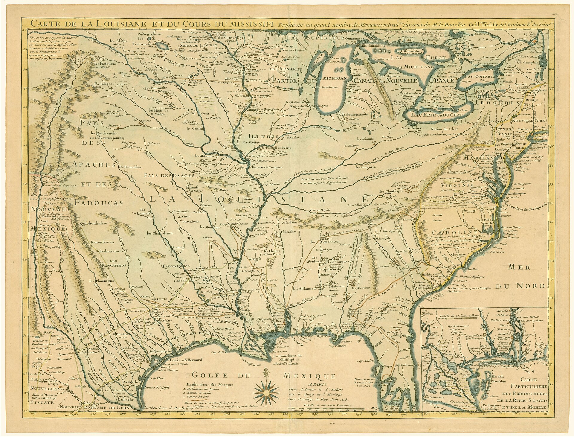
The expedition moved north through central Texas from August through early October 1759 — rough terrain, supply difficulties, and periodic skirmishes with smaller raiding parties along the route. By early October the force had reached the Red River corridor.
Objective
Parrilla’s orders were punitive and demonstrative: engage the Wichita-Caddoan peoples who had led the San Sabá attack, specifically the Taovaya, and demonstrate Spanish military reach into the southern Plains. The mission was to punish, recover prestige, and deter future coalition-scale resistance.
3. The Taovaya Village in 1759
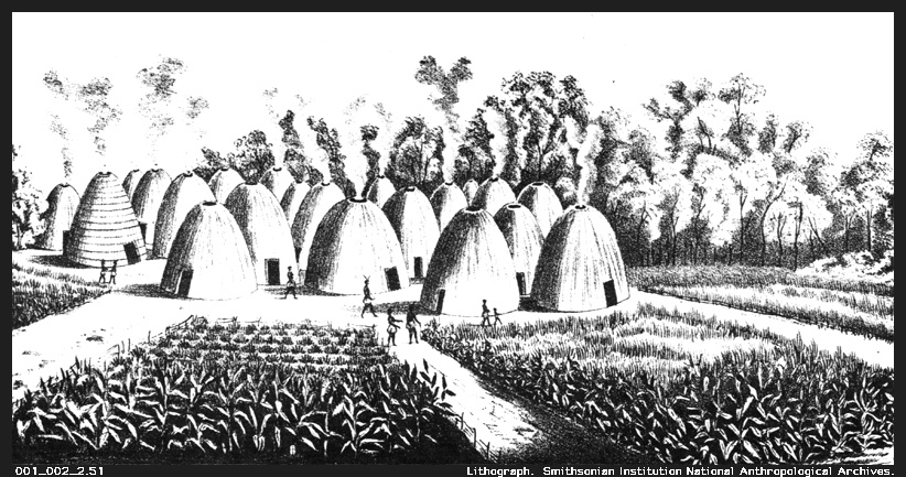
The village Parrilla’s intelligence had described was not the village his force found. The Taovaya had built one of the most sophisticated fortified settlements on the southern Plains.
Physical Defenses
Spanish after-action accounts describe in detail what their cannon could not breach:
- Earthen walls and wooden palisades — not a fence but a military barrier, constructed with vertical and horizontal timber reinforced with packed earth
- Defensive moat — ditch excavated around the fortified perimeter
- Prepared firing positions — elevated platforms and notches allowing defenders to fire from cover
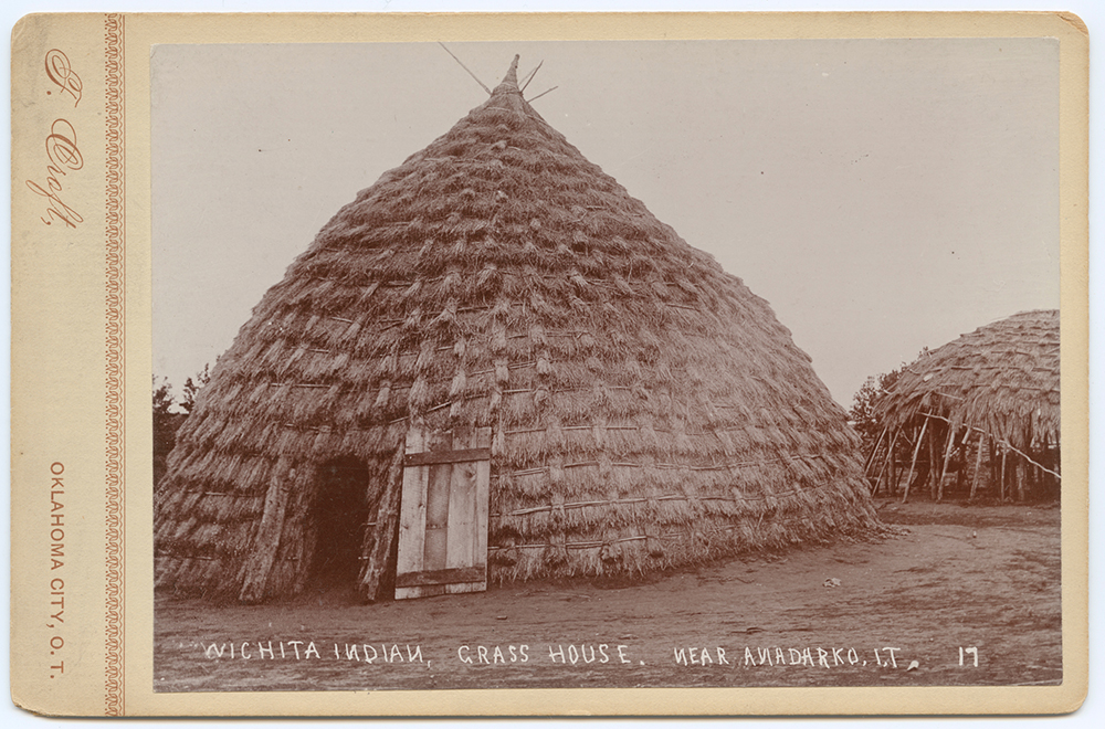
- Dome lodges within — the permanent grass-thatched circular lodges of Wichita architecture, each thirty to fifty feet across
Archaeological investigation of the Spanish Fort site has confirmed defensive ditches, palisade post-mold evidence, and traces of lodge foundations across the river terrace. These earthworks are what Anglo-American settlers later misidentified as “Spanish” construction.
The “Twin Villages” designation in later historiography refers to paired village clusters on the Red River terrace — likely reflecting social or kinship divisions within the Taovaya community positioned to support each other.
Firepower
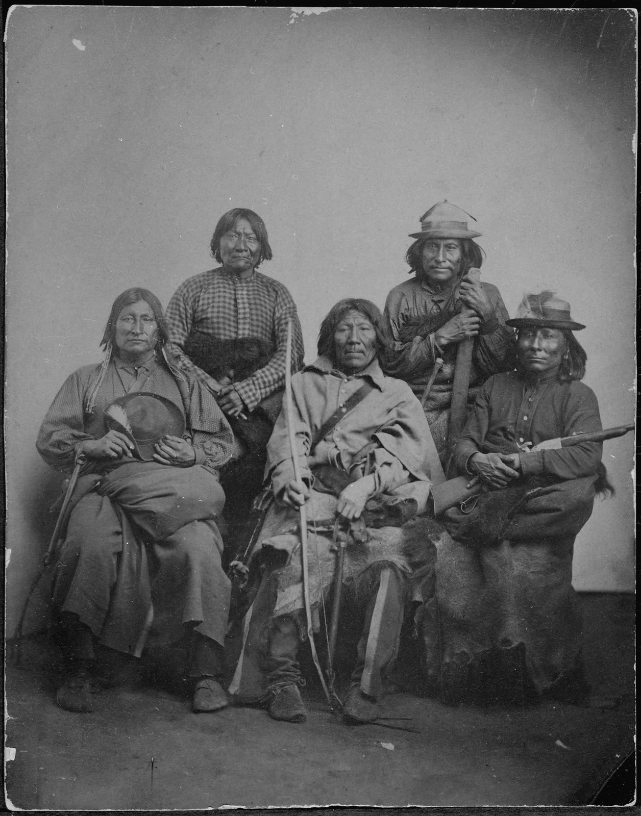
What made the Taovaya formidable beyond the earthworks was their access to French trade goods. French traders working up the Red River from the Louisiana post at Natchitoches had supplied the Taovaya with flintlock muskets, gunpowder, and lead. By 1759 the village’s defenders were among the best-armed Indigenous peoples on the southern Plains. A French flag was reported flying above the fortification when Parrilla’s column arrived — a deliberate declaration of alliance visible to the approaching Spanish force.
Allied Comanche Presence
Comanche bands had also gathered at the site. The Comanche-Wichita trade relationship, which connected the two peoples through horses and French trade goods across the middle decades of the century, produced a combined military force when the Spanish arrived. Comanche cavalry would prove critical in the battle’s outcome.
4. The Battle — October 7, 1759
Opening Moves
The Spanish column approached the Taovaya village in formation with cannon positioned forward. The fortifications visible from the approach were larger and more substantial than Parrilla’s intelligence had indicated. The force deployed.
The cannon opened fire. This was the moment the expedition had been planned around: European artillery against Indigenous walls. The palisades held.
Earthen berms backed by timber palisades absorbed cannonball impact in ways that mud-brick walls did not. The cannon were adequate for the tactical problem they had been designed for; they were inadequate for this one.
Four Hours
Spanish accounts describe approximately four hours of engagement. The features of that fighting, reconstructed from Parrilla’s dispatches:
- Musket fire from the earthworks — Taovaya defenders with French-supplied muskets returned fire from protected positions throughout the battle
- Comanche cavalry on the flanks — mounted warriors swept the open ground around the Spanish formation, preventing any outflanking approach and inflicting casualties on exposed units
- Spanish cannon continued — firing against the palisades without achieving a breach
- Ammunition and morale — both running in the wrong direction as the afternoon wore on
- Apache allies’ wavering — Spanish accounts note morale difficulties among the Lipan Apache contingent; Apache motivations against Wichita-Caddoan peoples were less acute than against Comanche, and the course of the battle offered them little incentive to fight harder
The mathematics of the engagement became clear: the Spanish could not breach the defenses, the defenders could fire from cover indefinitely, and the flanking cavalry threat made any sustained assault outside the Spanish formation impossible.
The Retreat
Parrilla made the decision to disengage. The force fell back. In the withdrawal, the baggage train was abandoned — the expedition’s supplies, provisions, and equipment left on the field. The two cannon were also left behind, captured by the Taovaya defenders. Artillery captured from a European force was not a routine outcome of Indigenous defense; these cannon were trophies of the first order.
Casualties
- Spanish killed: 19 (confirmed in Parrilla’s after-action report; some sources indicate more)
- Spanish wounded: 14 or more
- Spanish missing: several
- Taovaya and Comanche casualties: not recorded by Spanish clerks; likely relatively low given the defensive advantage of prepared earthworks
The force retreated southward, arriving at San Antonio in mid-October 1759.
5. Why This Battle Mattered
End of Spanish Military Expansion Onto the Southern Plains
The clearest consequence: no further Spanish military expeditions entered Wichita-Caddoan territory after 1759. Spain absorbed the defeat, maintained San Sabá presidio in its isolated position for a few more years, and eventually redirected its frontier strategy entirely. The presidio was ultimately abandoned. Missionary efforts moved south and west, away from the Plains nations who had demonstrated they could resist European force.
Diplomatic Reorientation
By the 1770s, Spain’s approach to the southern Plains nations had shifted from military projection to diplomatic accommodation. Athanase de Mézières, working after 1762 from Louisiana (which Spain acquired from France in the same period that French firearms were arming the Taovaya), negotiated with Wichita and Comanche peoples through trade and treaty rather than military pressure. The 1759 defeat was the primary reason for that shift.
French-Spanish Strategic Intelligence
The battle demonstrated to Spanish colonial authorities in concrete terms what French firearms distribution had accomplished: the Taovaya and their allies could match or exceed Spanish military capability when they held defensive position, possessed firearms, and had Comanche cavalry in support. This was strategic intelligence that shaped French-Spanish diplomacy through the remainder of the colonial period.
Indigenous Coalition Building
The defending force at the Taovaya village demonstrated that Wichita-Caddoan peoples and Comanche bands could act in effective military coordination against a common European threat, despite the complex relationships — including periods of conflict — between them in other contexts. The coalition defeat of Parrilla’s expedition strengthened both Taovaya prestige and the practical case for Comanche-Wichita cooperation.
A Century of Indigenous Control
For more than a century after October 7, 1759, the southern Plains north of the San Antonio line remained effectively under Indigenous control. Spanish, then Mexican, then Texan and American forces operated on the periphery. The 1759 battle established the terms of that arrangement. The southern Plains were not terrain that European powers could simply enter by force.
6. The “Spanish Fort” Misnaming
The most persistent legacy of the battle is also its most frustrating: the site of an Indigenous victory over Spanish forces is called Spanish Fort.
How the Name Arose
Anglo-American settlers arrived at the Red River bluff in the mid-19th century and found earthwork ruins. The earthworks were Taovaya — the same fortifications that had repelled Parrilla’s cannon. The settlers assumed they were Spanish military construction. By the time the misnaming was inscribed on maps and land records, correcting it required overcoming the inertia of established usage.
Contributing factors: the loss of Taovaya oral tradition through removal and epidemic; the Anglo tendency to attribute any pre-contact earthwork to “Spanish” activity; and the absence of anyone present who could say what the earthworks actually were before the name solidified.
The name “Spanish Fort” has persisted through scholarly efforts to correct it. The community today carries the name. This page uses it as a geographic referent — specifically, as a referent for an Indigenous victory over Spanish forces in 1759.
For the full site history including Anglo settlement, the Chisholm Trail era, and H.J. Justin’s boot shop, see Old Spanish Fort.
7. Documentation and Archaeology
Spanish Colonial Records
Parrilla’s after-action reports, provincial governors’ correspondence, and council documents in Mexico City form the primary written record. These sources are hostile-ledger accounts: written by the losing side to explain military failure to colonial superiors. They document Spanish troop dispositions and casualties accurately for self-reporting purposes; they do not document what the Taovaya defenders planned, thought, or remembered.
These records are available through Mexican and Spanish archives and through scholarly translations.
Modern Scholarship
- Bolton, Athanase de Mézières and the Louisiana-Texas Frontier, 1768–1780 — foundational reference
- Hämäläinen, The Comanche Empire (Yale University Press, 2008) — Comanche alliance context
- Newcomb, The Indians of Texas (University of Texas Press, 1961)
- TSHA Handbook of Texas — Ortiz Parrilla, San Sabá Mission, Spanish Fort entries
- Texas Beyond History (texasbeyondhistory.net) — Spanish Fort site documentation
Archaeology
The Spanish Fort site has been subject to archaeological investigation, though not comprehensive excavation. Defensive ditches, palisade post-mold evidence, and dome-lodge foundation traces have been confirmed. The site is recognized by the Texas Historical Commission. Texas Beyond History maintains documentation of archaeological survey results.
The two captured Spanish cannon remain a subject of folklore and occasional amateur search activity. Parrilla’s records confirm their abandonment; their subsequent disposition is undocumented and awaits archival research in Spanish colonial records in Mexico City and Sevilla.
8. The Big Picture
The Battle of the Twin Villages is the most significant pre-Anglo military event in Montague County’s history. A coalition of Taovaya defenders and Comanche allies — using European-supplied firearms, prepared earthwork defenses, and effective cavalry tactics — defeated a 600-man Spanish punitive expedition equipped with cannon. The battle established that the southern Plains were not terrain Spain could project military force across by conventional means. It closed a chapter in Spanish colonial ambition and opened the century of Comanche-Kiowa-Wichita dominance that preceded Anglo settlement.
The site is a Red River bluff in northern Montague County, twelve to fifteen miles north of Nocona. The earthworks are still there, in modified form, beneath the surface of a small unincorporated community with the wrong name on the map.
References
Texas State Historical Association. “Ortiz Parrilla, Diego.” Handbook of Texas Online. Retrieved 2026-05-06. https://www.tshaonline.org/handbook/entries/ortiz-parrilla-diego
Texas State Historical Association. “Ortiz Parrilla Red River Campaign.” Handbook of Texas Online. Retrieved 2026-05-06. https://www.tshaonline.org/handbook/entries/ortiz-parrilla-red-river-campaign
Texas State Historical Association. “The Attack on Mission Santa Cruz de San Sabá.” Texas Day by Day. Retrieved 2026-05-06. https://www.tshaonline.org/texas-day-by-day/entry/151
National Park Service. “Mission Santa Cruz de San Sabá and Presidio San Luis de las Amarillas.” Retrieved 2026-05-06. https://www.nps.gov/subjects/travelspanishmissions/mission-santa-cruz-de-san-saba-and-presidio-san-luis-de-las-amarillas.htm
Bolton, H. E. Athanase de Mézières and the Louisiana-Texas Frontier, 1768–1780. Arthur H. Clark Co., 1914.
Hämäläinen, P. The Comanche Empire. Yale University Press, 2008.
Newcomb, W. W. The Indians of Texas: From Prehistoric to Modern Times. University of Texas Press, 1961.
Texas Beyond History (texasbeyondhistory.net) — Spanish Fort and San Sabá site entries.
Related pages: Old Spanish Fort | Taovaya and Wichita Peoples | Comanche and Kiowa | Spanish-French Rivalry