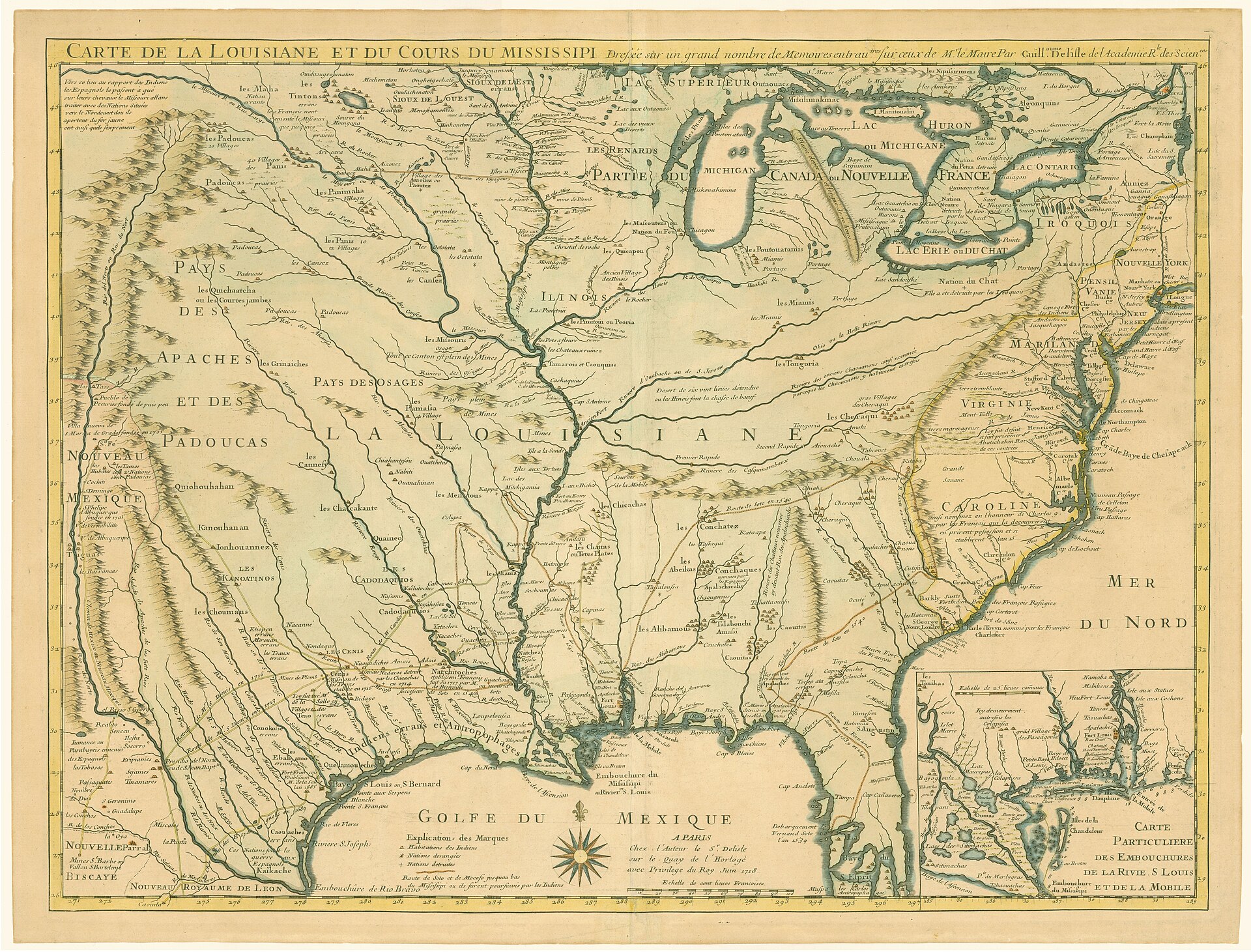
For most of the 18th century, two European empires claimed the territory that would become Montague County — and neither could hold it. Spain governed Texas from Mexico City through a network of missions and presidios; France governed Louisiana from New Orleans through a network of trade relationships with Indigenous peoples. The zone between them was never precisely drawn, never effectively controlled, and always contested. Montague County’s Red River corridor sat at the center of that contest.
What made the contest consequential — and what made the 1759 Spanish military defeat at Spanish Fort possible — was a single structural asymmetry: French traders gave firearms to their Indigenous allies. Spanish missionaries gave sermons.
What Spain Was Doing in Texas
Spain’s claim to Texas rested on paper going back to Cabeza de Vaca’s 1528–1536 wandering and Coronado’s 1540–1542 entrada into “Quivira,” a Wichita-affiliated region in central Kansas. By the early 18th century, the Spanish colonial presence in Texas had solidified around 3 instruments: missions (converting Indigenous peoples to Catholicism and Spanish subjects), presidios (military posts protecting missions), and civilian towns anchored at San Antonio.
The capital at San Antonio was founded in 1718. The eastern frontier post at Los Adaes (present-day Robeline, Louisiana) was established in 1716 specifically to counter French expansion from Louisiana. Spanish Texas had a total European population measured in the low thousands and a strategy that assumed Indigenous peoples would be peacefully incorporated through the Church.
That strategy failed on the southern Plains, catastrophically, in 1758 and 1759.
What France Was Doing in Louisiana
France’s Louisiana claim dated to La Salle’s 1682 declaration of the Mississippi drainage for France. New Orleans, founded in 1718, became the administrative center. But French Louisiana operated very differently from Spanish Texas: where Spain planted missions, France planted trading posts. Where Spain sought conversion, France sought commerce.
French traders worked up the Red River from Natchitoches — the principal French frontier post, established in 1714 just inside present-day Louisiana — and reached Wichita-Caddoan villages at the Red River. What they brought mattered enormously:
Goods flowing into Wichita-Caddoan villages from French traders:
- Flintlock muskets, gunpowder, lead balls, and replacement parts
- Iron and steel tools — knives, axes, hoes, awls, fishhooks
- Wool blankets (“Stroud” cloth) and linen
- Iron pots and kettles replacing ceramic vessels
- Glass beads for adornment and ceremony
- Brass and copper for craft and ornamentation
- Tobacco (European-cured varieties)
Goods flowing back to French traders:
- Buffalo robes and hides — the dominant commodity in the French Atlantic trade
- Deer hides for the European leather industry
- Bear grease used as lamp oil and lubricant
- Bois d’arc bow staves — the most valued bow wood on the southern Plains, native only to the Red River corridor
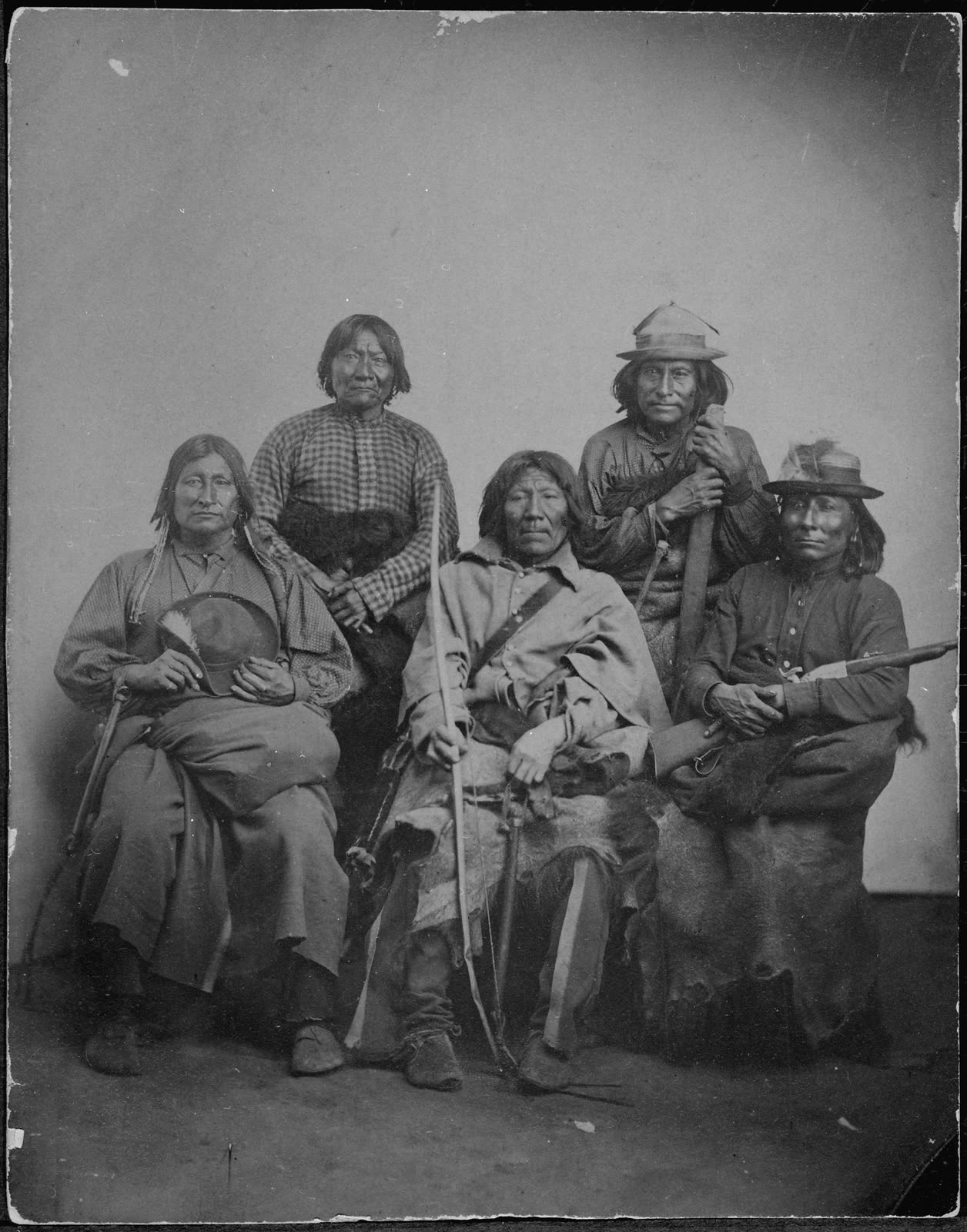
The trade gave Wichita-Caddoan peoples, and through them their Comanche trading partners, a significant military advantage over other regional peoples — including the Spanish.
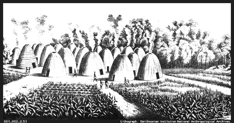
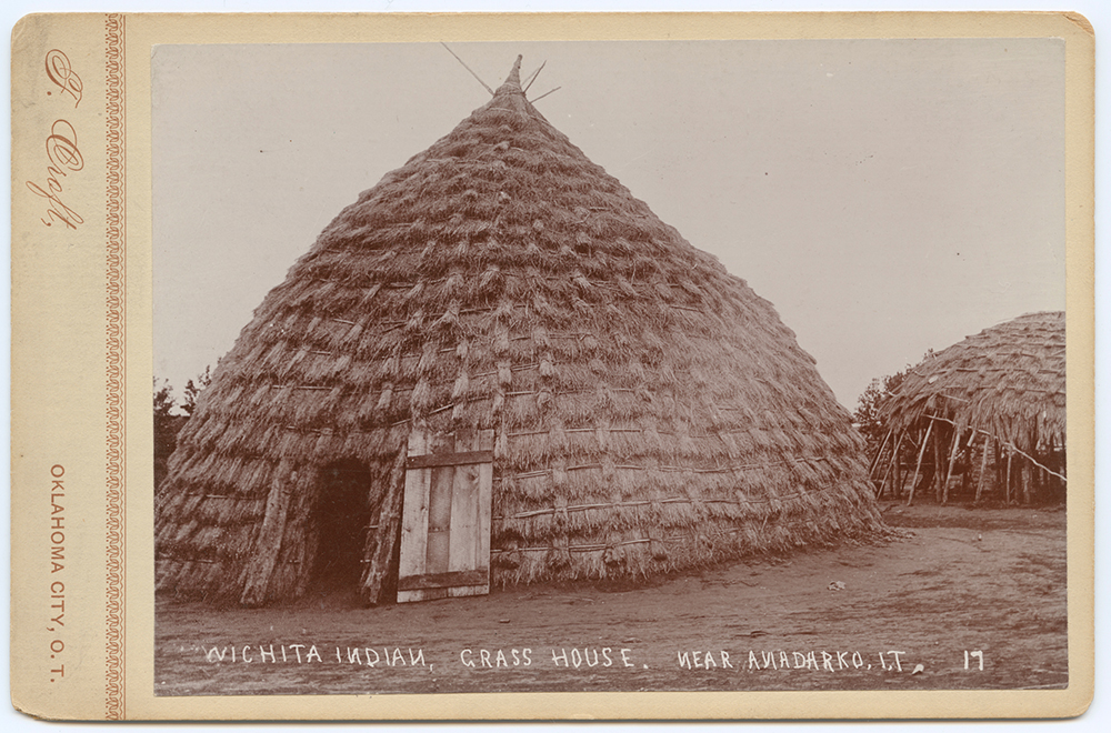
The Trade Triangle at Spanish Fort
The Taovaya village at Spanish Fort was the downstream terminus of the French trade network and the upstream interface with Comanche bands from the High Plains. This position made it the most geopolitically significant settlement in 18th-century interior north Texas.
The trade geometry worked like this: French traders brought European manufactured goods — especially firearms — north from Louisiana posts up the Red River to the Taovaya village. Comanche bands from the High Plains came to the Taovaya village to trade horses, buffalo products, and occasionally captives for agricultural surplus (corn, beans, sunflower oil) and, critically, for the French trade goods the Taovaya had acquired. The Taovaya sat at the pivot, profiting from both directions.
This “trade triangle” (French goods → Taovaya village → Comanche exchange) made Spanish Fort one of the most important commercial nodes in the 18th-century interior. It also meant that Spanish authority over the region was structurally undermined. Spain claimed the territory; France was supplying the people living in it with the weapons that would eventually repel Spanish forces.
[Smith, F. T. (2000). The Wichita Indians: Traders of Texas and the Southern Plains, 1540–1845. Texas A&M University Press. pp. 80–95.] [Bolton, H. E. (1914). Athanase de Mézières and the Louisiana-Texas Frontier 1768–1780. Arthur H. Clark Company. Vol. 1, pp. 48–63.]
The San Sabá Provocation (1757–1758)
The crisis that led to Spain’s military defeat in Montague County developed over two years. In April 1757, Spanish authorities established Mission Santa Cruz de San Sabá near present-day Menard, Texas. The mission’s purpose was to convert Lipan Apache peoples — bitter enemies of the Wichita-Caddoan and Comanche peoples — and extend Spanish presence northward toward the Plains.
From the perspective of the Taovaya and their Comanche allies, the mission’s protection of Lipan Apache was an act of strategic alignment with their enemy. On March 16, 1758, a coalition force estimated at approximately 2,000 warriors — Comanche, Taovaya and Tawakoni Wichita-Caddoan peoples, Tonkawa, and others — destroyed the mission and killed the Franciscan missionaries.
Spain’s response was inevitable: a major punitive expedition to destroy the Taovaya village, capture prisoners, and restore Spanish military credibility on the frontier.
[TSHA Handbook of Texas. “The Attack on Mission Santa Cruz de San Sabá.” tshaonline.org/texas-day-by-day/entry/151. Retrieved 2026-05-06.]
The 1759 Spanish Defeat
Colonel Diego Ortiz Parrilla assembled approximately 600 men — Spanish regulars, militia, presidio soldiers, Lipan Apache allies, Tlaxcalans, and mission Indians — and marched north from San Antonio in the summer of 1759. He brought two fieldpiece cannon, expecting to use them decisively against what he assumed would be an unfortified village.
On October 7, 1759, the Spanish force reached the Taovaya fortifications at what is now Spanish Fort, Montague County. The village was nothing like Ortiz Parrilla’s intelligence had described. The Taovaya had built earthen walls, a double-walled wooden palisade reinforced with packed earth, and a defensive moat. A French flag flew above the fortification. Comanche cavalry occupied the approaches.
The Spanish cannon fired for four hours and could not breach the palisades. Native defenders returned fire with French-supplied muskets, sallying repeatedly in coordinated formations. Comanche horsemen prevented any flanking maneuver. By the end of the engagement, at least 19 Spanish soldiers were killed and 14 wounded. Both cannon were abandoned when Ortiz Parrilla ordered retreat on October 25.
The Spanish defeat at Spanish Fort was the most significant European military loss to Indigenous forces in 18th-century Texas. It ended Spain’s efforts to extend military or missionary presence onto the southern Plains by force. The strategic calculus that had looked like a straightforward punitive mission turned out to rest on fundamentally incorrect intelligence about what French trade had made possible.
For the full military narrative of the battle, see Battle of the Twin Villages.
[TSHA Handbook of Texas. “Ortiz Parrilla Red River Campaign.” tshaonline.org. Retrieved 2026-05-06.] [Texas Beyond History. “Spanish Fort: A Taovaya Village on the Red River.” texasbeyondhistory.net. Retrieved 2026-05-06.]
Spain Acquires Louisiana — and Inherits France’s Problem (1762–1800)
In 1762, France ceded Louisiana to Spain as part of the Seven Years’ War settlements (formalized in the 1763 Treaty of Paris). This meant that both Texas and Louisiana were now Spanish provinces. The boundary dispute between the two empires became moot — administratively, it was a single empire.
But Spain had acquired Louisiana and with it France’s trade obligations to the Indigenous peoples France had armed. Spanish authorities at Natchitoches recognized immediately that cutting off the trade that kept Wichita-Caddoan peoples and Comanche bands diplomatically compliant was not a viable option. The French traders remained in place, now as Spanish subjects, and the trade continued.
Athanase de Mézières
The most consequential figure of the post-1762 Spanish-administered Louisiana period was Athanase de Mézières (ca. 1719–1780), a French-born military officer who served the Spanish crown at Natchitoches. De Mézières understood both the Indigenous diplomatic landscape and the trade networks that Spain had inherited. In the 1770s he conducted extensive diplomatic work with Wichita-Caddoan peoples and Comanche bands — negotiating peace agreements that the 1759 defeat had made necessary, formalizing trade relationships, and integrating Wichita-Caddoan peoples into a Spanish commercial sphere.
De Mézières’ work produced a period of relative stability along the Red River corridor through the 1770s and 1780s. It also represented Spain’s formal concession that military pressure on the Taovaya had failed and that diplomacy through trade was the only viable alternative.
[Bolton, H. E. (1914). Athanase de Mézières and the Louisiana-Texas Frontier. Vol. 1, pp. 123–145.] [TSHA Handbook of Texas. “Athanase de Mézières y Clugny.” tshaonline.org. Retrieved 2026-05-06.]
The American Succession (1800–1819)
The Spanish-administered period in Louisiana ended in stages. The 1800 Treaty of San Ildefonso returned Louisiana from Spain to France — a secret transfer Spain had tried to prevent. Three years later, in 1803, France sold Louisiana to the United States. The Texas-Louisiana boundary became the Spain–United States frontier.
The 1819 Adams-Onís Treaty settled the boundary: the Sabine River for the Texas-Louisiana line and the Red River from a specific point west as the Texas–Indian Territory boundary. That northern boundary, the Red River, is essentially the boundary that defines Montague County’s northern edge today.
The political succession meant that the framework of imperial rivalry — France vs. Spain, trade networks vs. missions — gave way to the entirely different dynamic of United States expansion westward, which approached the region with its own set of assumptions and pressures. Texas became part of independent Mexico in 1821, was lost to the Republic of Texas in 1836, and was annexed by the United States in 1845. By the time Anglo settlers arrived in what would become Montague County in the 1850s, the Spanish-French rivalry was 90 years in the past. But its consequences were still present in the landscape: the earthwork ruins on the bluff at Spanish Fort, the Comanche raiding economy that firearms and trade had helped build, and the absence of any viable Spanish or Franco-Spanish colonial presence north of San Antonio.
What the Rivalry Left Behind
The Spanish-French imperial contest along the Red River corridor produced outcomes that shaped everything that followed.
On the Indigenous side: Wichita-Caddoan peoples, and through their trade the Comanche, became the best-armed Indigenous peoples on the southern Plains south of Canada. The firearms competence, tactical sophistication, and diplomatic experience that Taovaya leaders developed in a century of playing two European powers against each other gave their successors tools that delayed Anglo-American settlement of north Texas by decades. The 1759 defeat stopped Spain; it took the Red River War of 1874–1875 to end the system the French trade had made possible.
On the landscape: The earthwork remnants of the Taovaya village at Spanish Fort are the physical residue of this history — the only surviving above-ground archaeological evidence of the 18th-century trade and military complex at the center of the Spanish-French contest. The misnaming of the site as “Spanish Fort” is itself a legacy of the rivalry’s erasure: Anglo-American settlers who found earthworks on the bluff in the 1840s attributed them to Spanish military activity because the Taovaya who built them were gone.
On the place names: “Natchitoches” persists in Louisiana from the French trading-post era. “Bois d’arc” — the French name for the bow wood that the Taovaya and their neighbors controlled — is still used in Montague County and along the Red River corridor, a linguistic artifact of French traders who watched Indigenous archers and asked what they were bending. The Red River’s French name, “Rivière Rouge,” survives in English translation.
The rivalry itself ended in 1762. Its consequences shaped this landscape for another century.
See Also
- Taovaya and Wichita Peoples on the Red River — Wichita-Caddoan peoples, lifeways, and the Spanish Fort village
- Battle of the Twin Villages — Full military narrative of the October 7, 1759 battle
- Old Spanish Fort — The site itself: archaeological heritage and Anglo settlement
- Spanish Fort — The ghost town community and Chisholm Trail era
References
[Bolton, H. E. (1914). Athanase de Mézières and the Louisiana-Texas Frontier 1768–1780. 2 vols. Arthur H. Clark Company.]
[Hämäläinen, P. (2008). The Comanche Empire. Yale University Press.]
[Smith, F. T. (2000). The Caddo Indians: Tribes at the Convergence of Empires. Texas A&M University Press.]
[Smith, F. T. (2000). The Wichita Indians: Traders of Texas and the Southern Plains, 1540–1845. Texas A&M University Press.]
[Texas Beyond History. “Spanish Fort: A Taovaya Village on the Red River.” University of Texas at Austin. texasbeyondhistory.net. Retrieved 2026-05-06.]
[Texas State Historical Association. “Athanase de Mézières y Clugny.” Handbook of Texas Online. tshaonline.org. Retrieved 2026-05-06.]
[Texas State Historical Association. “Ortiz Parrilla Red River Campaign.” Handbook of Texas Online. tshaonline.org. Retrieved 2026-05-06.]
[Texas State Historical Association. “Spanish Fort, Texas.” Handbook of Texas Online. tshaonline.org. Retrieved 2026-05-06.]
[Texas State Historical Association. “Taovaya Indians.” Handbook of Texas Online. tshaonline.org. Retrieved 2026-05-06.]
[Texas State Historical Association. “The Attack on Mission Santa Cruz de San Sabá.” Handbook of Texas Online. tshaonline.org/texas-day-by-day/entry/151. Retrieved 2026-05-06.]
[Weber, D. J. (1992). The Spanish Frontier in North America. Yale University Press.]