Spanish Fort sits at the end of Farm-to-Market Road 103 in northern Montague County, twelve to fifteen miles above Nocona on the Red River bluff. The place name is a misnomer. There was never a Spanish fort here. The earthworks Anglo settlers found when they arrived in the mid-1800s were not the remnants of a Spanish military installation — they were the defensive walls of a Taovaya fortified village whose defenders had beaten a Spanish army in 1759 and kept their home. The name encodes the misidentification. The history is more interesting than the name.
What Happened Here in 1759?
The Taovaya — a Wichita-Caddoan people who had built a substantial agricultural town on the Red River bluff sometime before 1750 — were not a people the Spanish colonial administration had expected to find well-armed. That was Spain’s error.
On October 7, 1759, Colonel Diego Ortiz Parrilla led roughly 600 soldiers — Spanish regulars, militia, and Lipan Apache allies — against the Taovaya village in retaliation for the 1758 destruction of Mission Santa Cruz de San Sabá. Parrilla brought two cannon. He expected an open-field engagement or an unfortified village. He found earthen walls backed by wooden palisades, a defensive moat, prepared firing positions, and defenders carrying French-supplied muskets. A French flag flew above the fortification.
The two Spanish cannon fired against the palisades for four hours and failed to breach them. Comanche cavalry swept the Spanish flanks throughout the engagement. Spanish casualties mounted. When Parrilla ordered the retreat, he left the baggage train and both cannon behind — captured by the Taovaya.
The Spanish killed nineteen men confirmed in the after-action report. The Taovaya’s casualty count was not recorded by Spanish clerks. The village held. No further Spanish military expedition entered Wichita-Caddoan territory after 1759.
The full account of the engagement is at Battle of the Twin Villages, the 1759 engagement that marked the limit of Spanish northward expansion in Texas.
The earthwork remains of the Taovaya fortification are still detectable in the landscape today. Texas Beyond History documents archaeological evidence of the defensive ditches, palisade post-molds, and dome-lodge foundations on the bluff terrace. The site is recognized by the Texas Historical Commission. The Wichita and Affiliated Tribes of Oklahoma — federally recognized descendants of the Taovaya — are the authoritative keepers of this history. Their perspective on the village and the battle is held in living oral tradition, not in Anglo-Texan archives.
Tribal consultation pending. Band-level genealogy, village archaeology, and Taovaya oral narratives await review by the Wichita and Affiliated Tribes, Caddo Nation, Kiowa Tribe of Oklahoma, and Comanche Nation. Claims from colonial and secondary sources reflect what those sources recorded, not Indigenous nations’ own accounts.
Spanish Fort in the Cattle Era
Anglo-American settlers arrived in Montague County in the 1840s and 1850s. The first confirmed Anglo burial at Old Spanish Fort Cemetery on the bluff dates to 1848. The settlers found earthwork ruins, assumed Spanish military origin, and the misnaming solidified. By 1857, when Montague County was formally organized, the community known as Spanish Fort was growing.
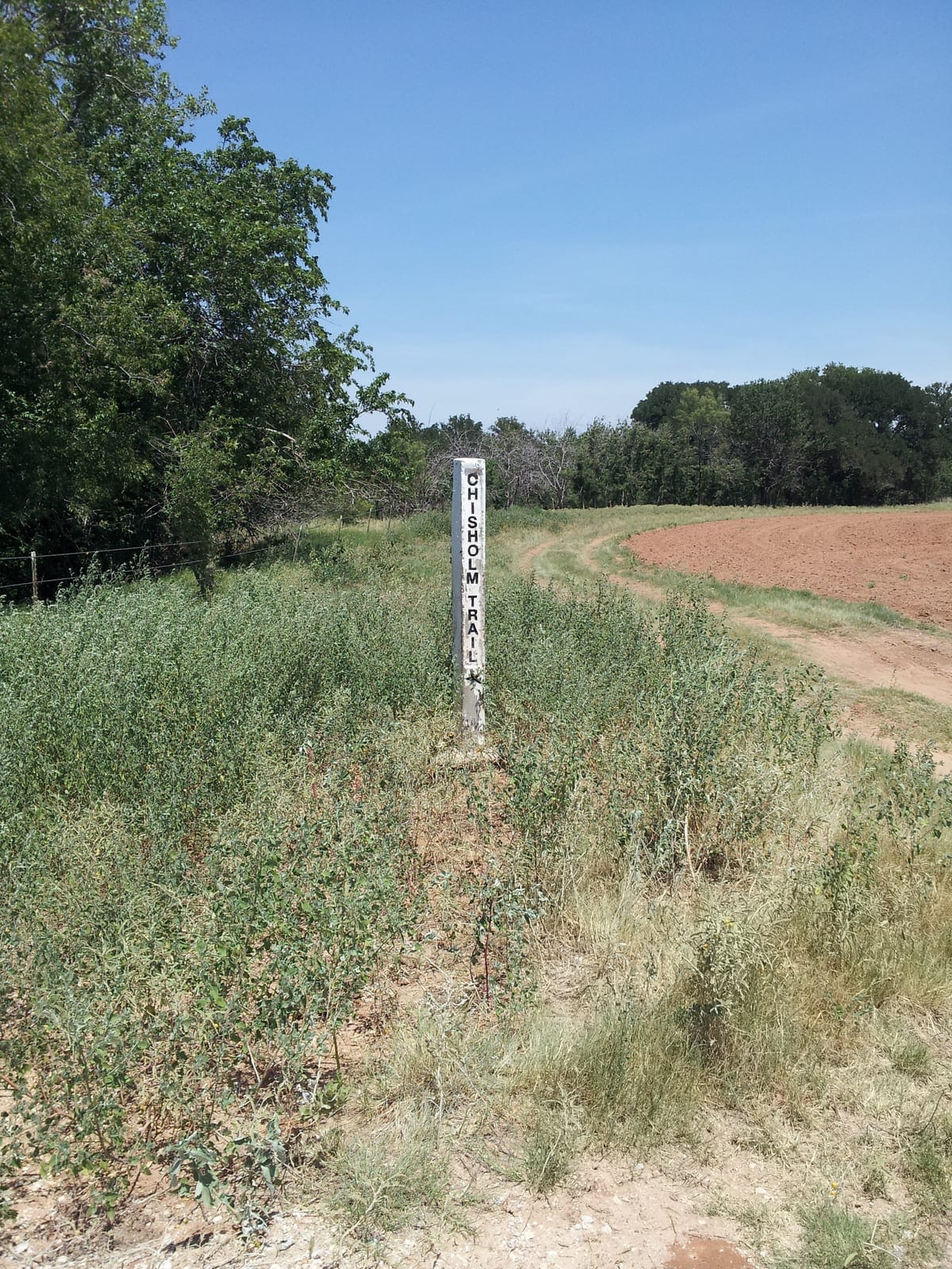
The cattle-trail era transformed the crossing. The primary Chisholm Trail ford across the Red River was at Red River Station, approximately ten miles west of Spanish Fort. Spanish Fort served as a secondary crossing, particularly when the Red River Station ford ran high. The commercial infrastructure that developed around the crossing — saloons, supply stores, stables — was trail-economy infrastructure, dependent on the seasonal movement of cattle herds northward into Kansas.
At the trail’s peak in the late 1870s, Spanish Fort had perhaps a few hundred residents and a busy main street during driving season. The community was a working frontier town: transient, commerce-driven, and tied to the rhythms of the Chisholm Trail and the Kansas beef market.
For more on the broader geography and archaeology of the Spanish Fort locality — including the Perryman Cemetery connection and Levi Perryman’s role in the region — see Old Spanish Fort.
How Did H.J. Justin Build a Boot Empire Here?
In 1879, a twenty-year-old Indiana-born cobbler named Herman Joseph Justin — “Joe” to everyone who knew him — opened a bootmaking shop in Spanish Fort, borrowing $35 from the town barber to finance the setup. The timing was right. Spanish Fort was a Chisholm Trail crossing community with a working population of cattle drovers who needed quality boots and could pay for them.
H.J. Justin built his reputation on custom work and on a mail-order innovation that extended his reach beyond the walk-in trade: customers mailed in paper foot measurements, Justin made the boots to specification, and shipped them back. The system built his business beyond Spanish Fort’s drover population alone. By the late 1880s, Justin boots were known across Texas.
The cattle drovers passing through Spanish Fort in the late 1870s and early 1880s were a mixed workforce — Anglo, Black, and Tejano and Mexican vaquero hands. Justin’s boot shop served the crossing trade. His ten years in Spanish Fort (1879–1889) produced the business foundation that would outlast the town.
The departure marked Spanish Fort’s trajectory. In 1889, Justin moved his operation to Nocona — newly founded on the GH&W Railway in 1887 — because the railroad access the mail-order business required was in Nocona, not Spanish Fort. When the most successful commercial operation on the bluff chose to relocate, it established the direction the community would take.
Justin married Anna Sophia Allen in 1887. He died July 14, 1918, in Nocona. His children, including daughter Enid Justin, carried the business and the boot-making tradition into the twentieth century.
Why Did Spanish Fort Decline?
The Chisholm Trail’s commercial lifespan effectively ended in 1884. Kansas quarantine laws targeting tick fever from longhorn herds had progressively restricted the driving routes from the south. The rail network’s expansion into Kansas and the Texas Panhandle made the long drive north redundant. Spanish Fort, which had no railroad and no agricultural diversification sufficient to replace the trail economy, began its contraction immediately.
Justin left for Nocona in 1889. Nocona’s founding on the GH&W Railway in 1887 had already pulled commerce east. Without the drovers, without the bootmaker, without the seasonal trade that had made the crossing a destination, Spanish Fort contracted around its remaining permanent residents.
The 20th-century trajectory followed the arc common to bypassed trail-era communities across north Texas: declining population, closing businesses, deteriorating structures, and the gradual return of the land to cattle pasture and cedar brush. The community that had perhaps a few hundred residents at its peak contracted to a handful of ranching families.
What Remains of Spanish Fort Today?
Spanish Fort today is a small unincorporated community at the end of FM 103 — a few residences and working ranches above the Red River bluff. The Old Spanish Fort Cemetery continues as a maintained burial ground with documented burials from the 1840s onward. Earthwork remnants from the Taovaya village are visible in some areas; the archaeological site is recognized by the Texas Historical Commission and documented through Texas Beyond History’s scholarly resources.
The physical character of the place makes the historical weight easy to underestimate on first approach. Quiet, isolated at a road’s end, with a red-sand river in the bottom. The bluff is the same bluff where the Taovaya palisade held off Parrilla’s cannon in 1759. The ground that received D. Wood’s body in 1848, that Justin paced while taking boot measurements from trail-weary cowboys, is still there under the grass.
For visitors: no formal interpretation, no visitor center. A cemetery, a river view, and the accumulated history of a place that outlasted every purpose it was built for.
The nearest service town is Nocona, approximately twelve to fifteen miles south. For Nocona’s full town profile and visitor services, see the Nocona town hub.