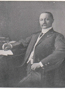
Joseph A. Kemp was a Wichita Falls businessman and civic leader whose investment decisions had lasting consequences for Montague County — not because he lived here, but because of where the oil was.
This biography rests on the TSHA Handbook of Texas and regional oil history files. Kemp’s birth date, death date, early career detail, and full biographical profile require primary-archival research at the Wichita Falls historical society and TSHA. The biography as presented here is thin by design — the sources consulted do not support more, and this site does not fabricate biographical detail. The TSHA Handbook of Texas “Joseph A. Kemp” entry is the authoritative secondary source for a fuller profile.
Who Was Joseph A. Kemp?
Joseph A. Kemp was a north Texas civic entrepreneur of the late 19th and early 20th centuries. His base was Wichita Falls, where he was involved in banking, real estate, water supply, and transportation. He was the kind of figure who built city infrastructure — not just one business, but the systems a growing city needed. Lake Kemp in Baylor County is named for him, a reflection of his role in Wichita Falls’ municipal water supply development.
His specific birth date, birthplace, family background, and early career details are documented in the TSHA Handbook of Texas and in Wichita County historical records, but are not available in the sources consulted for this article. They should not be fabricated.
What Was the K-M-A Land Partnership?
In 1912, Kemp formed a land partnership with two associates — W. Munger (some sources indicate S.I. Munger and H.M. Munger were involved) and Reese S. Allen — and purchased approximately 1,000 acres in an area they anticipated might hold petroleum.
The timing was not random. Oil had been discovered at Electra (1911) and Burkburnett (1912) in neighboring Wichita County. Geological speculation about a broader petroleum-bearing zone in north Texas was active. The Kemp-Munger-Allen play was a patient speculative investment in land that might, eventually, prove productive.
It took 19 years to find out.
By the 1920s, the partnership had organized as K-M-A Oil Company with approximately $50,000 in capitalization. They drilled and held leases through the decade, navigating the uneven economics of 1920s oil exploration and the early Depression years. The biographical details of Munger and Allen are thin in available sources — both are less documented than Kemp.
What Was the KMA Oilfield Discovery?
The KMA Field actually has two discovery phases:
1919 shallow discovery: The Kemp-Munger-Allen Oil Company, formally established in January 1919, completed its first flowing well in October 1919. Shallow production continued through the 1920s, peaking at over 7,000 barrels per day by August 1921, before saltwater intrusion created production challenges.
March 11, 1931 deep discovery: The Deep Oil Development Company drilled a well to approximately 3,800 feet in the Strawn formation and confirmed commercial petroleum. This deep discovery during the Great Depression revitalized the field, driving development through the 1930s and into a production peak in the 1940s.
The KMA Field ultimately encompassed approximately 135,000 acres with 3,000+ wells, straddling the Montague-Wichita-Archer county boundary. It is the principal petroleum resource in or adjacent to Montague County — but its geographic extent means that Montague County holds only a portion of the field, with Wichita and Archer counties holding the remainder.
See also: the KMA Oilfield article (internal link: kma-oilfield) for the full field history.
What Was Kemp’s Connection to Montague County?
Kemp’s MoCo connection is functional, not residential:
- He never lived in Montague County
- He did not found any MoCo town or institution
- His primary business operations were in Wichita Falls
The KMA Oilfield’s boundary with Montague County gave MoCo landowners with productive leases access to royalty income. County tax revenue from production within the MoCo portion of the field contributed to county finances. MoCo workers found employment in field development and operation.
The field that bears his initials — K-M-A — touches Montague County, and that touch was economically significant. But calling Kemp a Montague County figure overstates the connection. He was a Wichita Falls figure whose investment happened to straddle a county line.
What Is Kemp’s Legacy?
The clearest legacy is Lake Kemp in Baylor County — a water supply project that carries his name into a context unrelated to oil. In Wichita Falls itself, his civic contributions extended across multiple sectors; the specifics are in Wichita County historical materials rather than in the sources available here.
In Montague County, the legacy is the oilfield. The KMA Field continues to produce at reduced levels into the 21st century. The economic transformation it brought to north Texas landowners in the 1930s and 1940s — royalty income arriving during the Depression, when cotton prices had collapsed and cattle revenues were thin — was real and lasting.
Kemp’s story for MoCo purposes is the story of capital patient enough to hold speculative land for 19 years and skilled enough to develop it when the geology proved out. His name is on the field; the field’s effects are on the county.
Birth and death dates for Joseph A. Kemp are not confirmed in the sources consulted for this article and are omitted rather than fabricated. The TSHA Handbook entries for “Joseph A. Kemp,” “KMA Field,” and “Lake Kemp” are the authoritative secondary references for a fuller profile. Research at Wichita Falls historical society archives would substantially expand this biography.
See also: Nocona | Enid Justin | People of Montague County